
Mappedin
All-in-one indoor mapping platform that uses AI to create, edit, and maintain interactive 3D maps with real-time navigation and collaboration.
Community:


Product Overview
What is Mappedin?
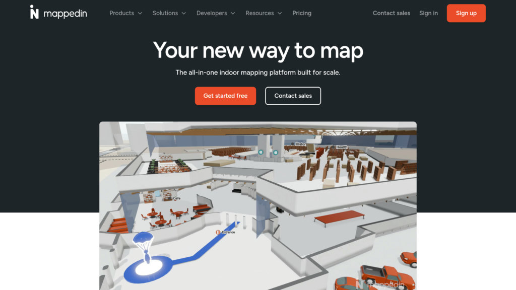
Mappedin is a scalable indoor mapping solution designed to digitize venues and provide accurate, interactive 3D maps for wayfinding and spatial data management. It leverages AI to automate map creation from floor plans, enabling quick transformation of static layouts into fully navigable digital maps. The platform supports real-time updates, multi-floor navigation, and rich location data, making it suitable for diverse industries such as airports, malls, offices, and emergency response. Mappedin also offers developer SDKs and APIs for custom integrations, empowering businesses to embed indoor maps into websites and apps while maintaining up-to-date spatial information.
Key Features
AI-Powered Map Creation
Automates the conversion of floor plans into precise digital maps by detecting walls, doors, rooms, and pathways, significantly reducing manual effort.
Interactive 3D Maps with Wayfinding
Provides detailed 3D visualizations with turn-by-turn indoor navigation, multi-floor routing, and real-time positioning for seamless user experience.
Real-Time Updates and Collaboration
Enables live editing and map maintenance with role-based permissions, draft and publish modes, and team collaboration tools to keep maps accurate.
Extensive SDKs and APIs
Offers developer tools to embed maps into apps and websites, customize map appearance, and integrate with external data sources for enhanced functionality.
Advanced Analytics and Insights
Tracks visitor behavior and map usage to provide actionable data for optimizing space management and improving user engagement.
Accessibility and Multi-Platform Support
Supports offline mode, right-to-left text, and works across devices including mobile, web, kiosks, and integrates with existing software platforms.
Use Cases
- Retail and Shopping Malls : Enhances shopper experience with interactive directories, product search, and navigation to stores and promotions.
- Airports and Transportation Hubs : Assists travelers with real-time wayfinding, flight data integration, and navigation through complex terminals.
- Corporate and Office Spaces : Facilitates space management, visitor navigation, and resource allocation within multi-floor office buildings.
- Emergency Response and Safety : Provides first responders with detailed indoor layouts, key safety equipment locations, and real-time navigation to improve situational awareness.
- Events and Stadiums : Improves visitor flow and safety with digital maps, point-of-interest search, and indoor positioning during large-scale events.
FAQs
Mappedin Alternatives

Hi3D
All-in-one 3D maker platform converting images to print-ready models with automated mesh repair, splitting, and slicer integration.

Canopy
Comprehensive parental control app that filters inappropriate content in real-time and provides family digital safety features.

PlantIn
AI-powered plant identification and care app with personalized care plans, disease diagnosis, and expert botanist support.

Photofeeler
Crowd-sourced photo feedback platform providing unbiased, trait-based ratings to optimize professional, dating, and social profile images.

Immich
High-performance, self-hosted photo and video backup and management solution with advanced AI-powered search and facial recognition.

Zoo Design Studio
Professional CAD platform with Text-to-CAD capabilities for generating precise engineering models from natural language descriptions.

Remeshy
Browser and mobile platform for generating custom 3D printable STL files from text or images, with built-in mesh repair and optimization.

Facia.ai
Advanced facial recognition platform delivering rapid and accurate identity verification with robust liveness detection and anti-spoofing capabilities.