
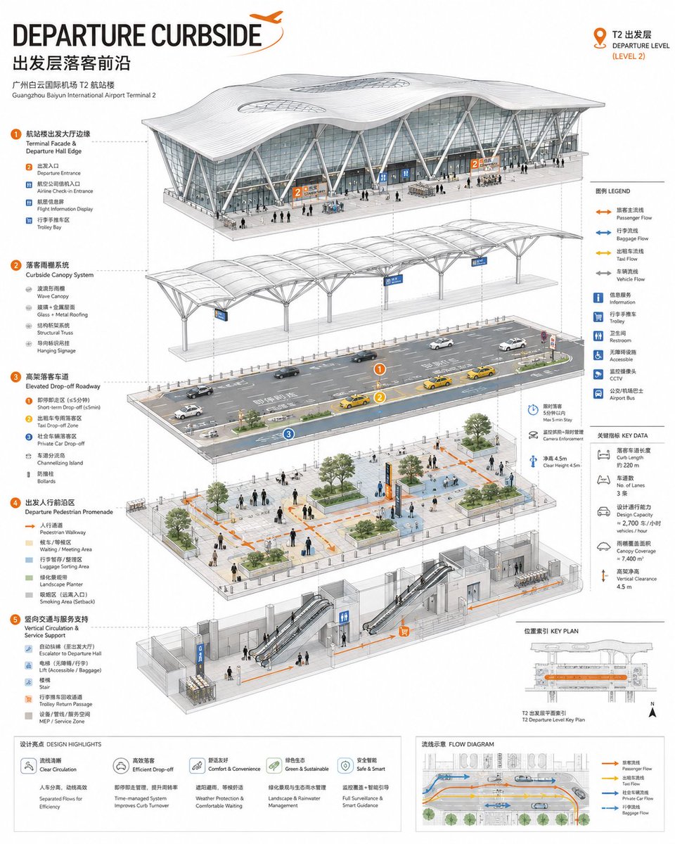
Based on the space name, space type, and reference materials I provide, generate a "professional spatial axonometric infographic / layered axonometric design diagram." Project name: {fill in the name, e.g., Guangzhou Baiyun Airport T2 / a commercial complex / a campus library / an urban park / a hotel lobby} Space type: {fill in, e.g., airport transport hub / commercial space / campus building / park landscape / exhibition space / hotel space / urban plaza} Spatial node to break down: {fill in one specific area, e.g., departures-level drop-off zone / arrivals pick-up zone / commercial atrium / campus entrance / children's activity area / hotel lobby / pavilion entrance hall} Reference materials: I may upload floor plans, satellite imagery, real photos, sections, functional descriptions, or style references; please consider them comprehensively. Image requirements: Generate an axonometric infographic on a white background in a professional architectural-portfolio style. The composition must be a layered axonometric or sectional axonometric structure, not an ordinary rendering. Break this spatial node into clear spatial layers and functional systems so the viewer instantly understands how the space is organized, used, and flows. Show in the image: 1. Building / site base interface 2. Main functional areas 3. Pedestrian / vehicle / circulation / service flow lines 4. Key facilities, nodes, entrances, waiting areas, service areas 5. Landscape, paving, furniture, signage, small human figures, vehicles, or related scale elements 6. Numbered callouts, legend, arrows, flow lines, small key-data cards 7. A well-designed English main title + Chinese subtitle Visual style: clean white background, professional architectural portfolio layout, exploded axonometric diagram, sectional axonometric diagram, architectural infographic, thin grey linework, light grey building mass, dark grey hardscape, soft green landscape, subtle shadow, orange and blue functional highlights, numbered callouts, bilingual labels, legend, key plan, flow diagram, small human figures, vehicles, trees, wayfinding signs, refined editorial title design. Information density: The image should carry rich layered information, color markers, functional annotations, and legend explanations, while overall staying refined, clean, and orderly. Not too empty, not like an ordinary rendering, and not a chaotic pile of information. Important constraints: If reference materials are insufficient, a conceptual design expression is acceptable, but do not pretend it is a survey-grade reconstruction. Real locations may be expressed in a designed way based on uploaded materials and public impression, without requiring fully precise restoration. The final image should be a "spatial logic diagram," not a photorealistic rendering.